Survey Section
- Implementing street cadastral work.
- Street marking with Dura Electricity Company to implement columns, towers and networks along the street path.
- Follow up on marking the path of the streets before starting the construction of the streets.
- Continue teaching the street path with the
Palestinian Telecommunications Company. - Surveying works for schools and government facilities.
Urban planning
- Work on expanding the city’s structural plan.
- Following up on information transactions, including physical inspection, determining street boundaries, and archiving the transaction in office and electronically.
- Follow-up of secretion transactions, which includes inspecting, auditing and approving the transaction.
- Follow up on explanations of land plots and responses to them.
- Follow up on updates to the property registry in coordination with the South Hebron Property Department.
- Paper and electronic archiving of secretion plans and modified streets and updating them on the structural plan and cadastral basin.
- Follow up on the completion of conformity certificates and correct the owner’s name.
- Follow up on work on municipal property, including plots of land and buildings.
- Photocopying a document including (structural plan, secretion approval transactions, information provision transactions, cadastral basins)
a future vision :-
completing a detailed structural plan for the city.
Department of Studies and Projects Design
It is the department entrusted with preparing studies, documents and plans for building and public facilities projects that the municipality implements or supervises.
The department includes two divisions: the Studies Division and the Projects Design Division. The tasks of the two divisions are as follows:
Tasks of the Studies Division:
- Developing proposals for development projects and linking them to the organizational structure chart.
- Follow up on proposed projects included in the strategic development plan.
- Cooperating and coordinating with relevant ministries and institutions to develop future
plans for all development and investment projects that the city needs. - Preparing concept papers.
- Preparing final studies.
- Preparing preliminary architectural designs.
Tasks of the Project Design Division:
- Preparing structural designs.
- Preparing detailed construction plans.
- Preparing technical specifications.
- Preparing bills of quantities and complete tender documents.
- Preparing the timetable for the implementation stages.
- Estimated cost calculation.
- Follow up on the tender until the award stage is completed.
Organization chart
The municipality was instructed to prepare a structural plan that shows the distribution of the main areas in the city and how they communicate with each other. The structural plan is considered closely related to the development of the city and its urban, economic and social planning, which adopted details and goals such as the size of the city, the aspirations of the community, current challenges and expected future developments, and the main goal of this is to create an environment A sustainable urban development that meets the needs of the city’s residents in the best possible way through:
- Initiating the preparation of the modern structural plan for the city of Dura in 2019 by municipal teams in the Planning Department
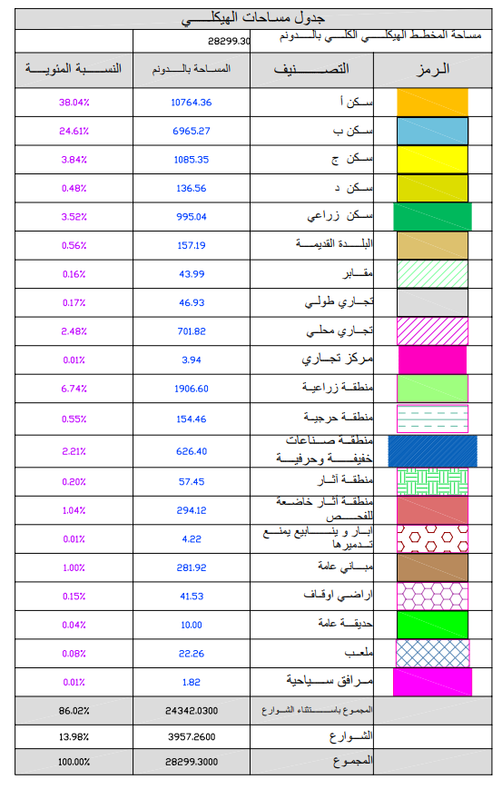
The plan approved in 2003 was expanded from an area of 15,251 dunums to a new area of 28,299 dunums, to the limits of Manaqq C.
- The work on the plan was completed in coordination with all parties involved in the various ministries
- The plan was approved by the local committee and certified by the demarcation approval from the Ministry of Local Government (Geomlj).
- The plan has been approved by the Ministry of Transport and Communications
- Follow-up is underway to complete the certification of agriculture and antiquities as soon as possible and submit a referral to the Local Government Directorate to complete the project.
Attached is a table specifying the classification of the areas, their areas, their percentages, and the total area of the proposed structural plan
Regarding the settlement, a plan is attached that shows the municipality’s boundaries, the boundaries of the completed and uncompleted basins and basins, the areas and completion rates.

